Live Cam Earth Map - GPS Cam
- 4.1
- Rating
- 1.00M
- Installs
- Free
- Price
 Analysis by App-foxy
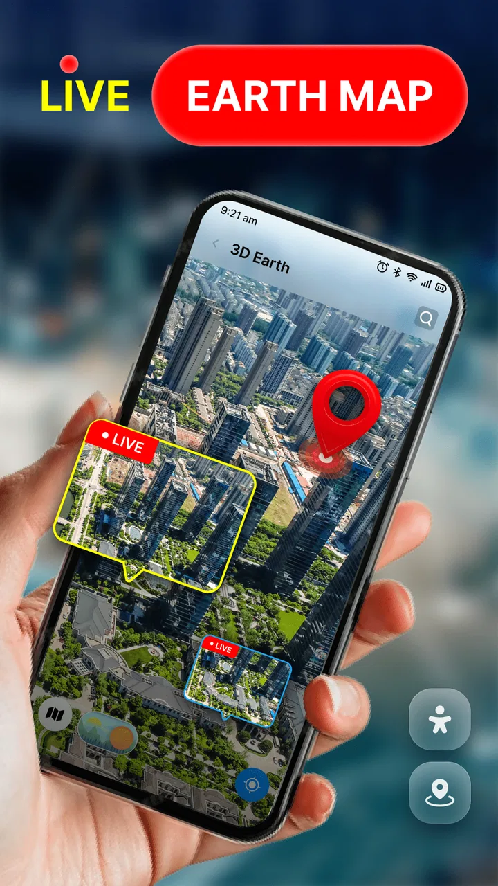
I opened Live Cam Earth Map - GPS Cam expecting a lightweight way to explore places visually, and that is exactly the role it seems designed to fill. This is a free Maps & Navigation app from GambiSoftVn that focuses on discovering attractions around the world through a live-camera-style map experience. It is not the kind of tool I would use as my only navigation aid, but it can make the first stage of planning a trip more visual and enjoyable.
The starting point is simple: I have a destination in mind, but I do not yet know what deserves attention. Instead of beginning with a conventional street map full of roads, pins, and route choices, I use this app as an exploratory layer. Its short store description, “Live Cam Earth Map,” sets the tone. The emphasis is on looking around and finding interesting places rather than managing a detailed journey from door to door.
From curiosity to a practical destination shortlist
When I move from browsing to planning, I try to turn visual curiosity into a shortlist I can actually use. I keep the places close enough to belong to one outing, then check routes and practical details in a navigation app before committing. That small handoff helps me avoid collecting more possibilities than the day can hold.
You May Also Like

 AccuWeather: Weather Radar
AccuWeather Review: A Quick, Clear Forecast for Everyday Decisions
For everyday plans, the best forecast is the one you can understand quickly. AccuWeather makes rain timing, radar, and local conditions easy to act on, with a few trade-offs.

 Hill Climb Racing
Why Hill Climb Racing Still Turns Crashes Into One More Run
A tiny car, a bumpy hill and one more upgrade: Hill Climb Racing keeps resurfacing because its simple chaos makes every near-miss feel personal.

 AliExpress - Shopping App
AliExpress Makes Global Shopping Feel Personal, but Shoppers Bear the Risk
AliExpress turns a global marketplace into a pocket-sized discovery engine. Its reach is useful, its shopping loop compelling, and its trade-offs easy to miss.

 Lords Mobile: Kingdom Wars
Lords Mobile Is a Kingdom-Building Routine, Not a Quick Match
A case-by-case verdict on the building, battles, device demands, and social commitments that make Lords Mobile rewarding for some players and exhausting for others.

 PDF Scanner app - TapScanner
TapScanner Makes Paperwork Easier to Capture, Check, and Share
TapScanner makes scanning with a phone feel less like a rescue operation and more like a dependable step in getting work done. Its capture tools are useful, though not flawless.

 Block Blast!
 Shows How Much a Puzzle Game Can Leave Out
A quiet grid game shows why puzzle players increasingly value instant clarity, repeatable skill and low-pressure play—and where the genre still needs to catch up.
More From Our News Desk
View All News


Beginning with visual discovery
My first useful workflow is to treat the app as a browsing tool. I start with a broad idea such as a city, landmark area, or region, then move through the map looking for famous attractions. That approach works better than opening it with a precise transport question. If I already know the exact station, hotel, and arrival time, a traditional navigation service is usually more efficient. If I am still asking myself “what is worth seeing here?”, the visual presentation has more value.
This distinction matters because the app’s strongest contribution is not necessarily the final route. It helps turn an unfamiliar place into something easier to imagine. I can use it before booking activities, while comparing neighborhoods, or when deciding whether a short stop is worth adding to a larger itinerary. Think of it as a discovery step before detailed navigation, not a complete replacement for every map tool on a phone.
For a realistic everyday example, imagine that I am spending an afternoon in a city I do not know well. I have a free block of time but no fixed plan. I open the app, inspect attractions in the surrounding area, and create a mental shortlist of places that look practical to visit. I then hand that shortlist to my usual map or transit app to check walking time, public transport, opening details, and the best order. That handoff is where this app fits naturally.
Moving from a broad view to a useful choice
The next step is narrowing the experience. Rather than jumping randomly between distant locations, I find it more useful to work in one geographic cluster at a time. I look for attractions that could reasonably belong to the same outing, then compare their visual appeal with the time available. This prevents the common mistake of collecting impressive places that are scattered too far apart to visit comfortably.
One non-obvious benefit of this workflow is that it changes how I plan. A standard map encourages me to think in terms of roads and distances first. Live Cam Earth Map encourages me to think in terms of visual interest first, then verify logistics elsewhere. That order is useful for spontaneous weekends, family outings, and destination research, but less useful for a commuter who already knows the route and simply needs the fastest arrival.
I would also use it when someone else is helping choose the destination. Showing an attraction through a visual map can make a conversation more concrete than reading a list of names. A friend can react to the setting, nearby landmarks, or the general character of an area, and we can then move the agreed choice into a more conventional planning tool. The app therefore works well as a shared decision-making aid, even though the final practical checks still belong elsewhere.
Handling the handoff to other tools
The handoff is the most important part of getting value from this app. Once I find a place that interests me, I record its name or location in the same way I would with any visual reference. I then verify the details using a service built for route planning and current local information. This two-stage method avoids asking one app to solve two different problems.
For navigation, the usual alternatives remain stronger when I need turn-by-turn guidance, traffic awareness, transit changes, saved addresses, or a precise arrival estimate. A dedicated map service is also the better choice when I am already standing on a street and need immediate instructions. Live Cam Earth Map is more comfortable earlier in the process, when I am gathering ideas and deciding what deserves a closer look.
There is a practical trade-off here: every handoff adds a little friction. I may need to copy a place name, search for it again, and confirm that I selected the correct location. That is manageable for a small sightseeing plan, but it becomes tedious when I am building a long itinerary. My advice is to use the app for a short, focused shortlist rather than attempting to turn every visible attraction into a separate saved destination.
What the visual approach changes
The live-camera concept gives the app a different feeling from a conventional map. Instead of treating the world as a collection of lines and labels, it invites me to explore places as scenes. That can be especially helpful when I am choosing between similar destinations and want an immediate sense of what might make one more appealing than another.
Still, a visual impression should not be mistaken for a complete visit preview. A camera-style view can help me recognize a landmark or understand its surroundings, but it does not replace checking current access conditions, local opening information, weather, accessibility, or crowd levels through appropriate sources. I use the app to create interest and orientation, not as proof that a location will suit every traveler.
This is also where expectations need to stay realistic. The app’s store summary promises discovery of famous attractions around the world, and that is the right way to understand it. I would not install it expecting a professional geographic information system, a full travel organizer, or a specialized offline navigation package. Its usefulness comes from combining a map context with visual exploration, not from covering every travel task.
Everyday scenarios where it earns a place
For a first-time visitor, the app can help transform an empty afternoon into a basic plan. I can browse nearby attractions, identify a few that match my interests, and then check the practical route separately. The outcome is not a finished itinerary generated automatically; it is a more informed starting point that reduces the feeling of choosing blindly.
It can also help before a family trip. Children or less enthusiastic travelers may respond better to seeing possible places than to hearing a list of names. I can use the visual exploration stage to agree on one or two stops, then switch to another service for travel times and scheduling. That keeps the decision process engaging without pretending that the app handles the entire day.
A third use is local exploration. Even when I am not traveling, I can use the app to rediscover attractions in a nearby city or region. The visual format encourages me to look beyond the places I already know. The important limitation is that I still need another source for details that change frequently, so I treat the discovery as a prompt for further checking.
Performance expectations and device fit
The app is available at no cost and is rated for Everyone, which makes it easy to try without committing money or choosing a specialized age category. It supports devices running Android 7.0 or later. That broad compatibility is helpful for people using older Android hardware, although the quality of the experience will still depend on the phone’s screen, responsiveness, and connection conditions.
The current version is 67.0, and the app has passed the one-million-install mark. Its average rating is 3.9 from roughly 842 ratings, with 59 written reviews. I read those figures as a sign of a usable but not universally loved experience: enough adoption to show that the concept appeals to many people, while the rating suggests that expectations and real-world results may vary. I would try it personally before building an important trip around it.
Because the experience is map- and camera-oriented, I prefer using it when I have time to look rather than while walking through a busy area. Exploring on the move can divide attention at exactly the wrong moment. My better workflow is to browse before leaving, note the places that matter, and use a dedicated navigation tool once I am outside.
Where the workflow breaks
The first breaking point is precision. When I need an exact route, a reliable arrival estimate, or a sequence of transport connections, this app is not the right primary tool. The visual discovery layer may help me select the destination, but the operational part of the journey belongs to a service designed around live navigation.
The second is information freshness. Attractions can change access arrangements, hours, entrances, or surrounding conditions. A visual map can remain useful for orientation while still being insufficient for a time-sensitive visit. I always verify important practical details separately, especially when the outing involves reservations, limited time, or accessibility needs.
The third is scale. Browsing famous attractions around the world is enjoyable, but a large collection of possibilities can become distracting. If I keep moving from one distant point to another, I lose the original purpose of the search. The best remedy is to define a small question before opening the app: “Which places near this area are worth considering?” A focused question turns the broad map into a manageable planning aid.
There is also a mismatch for users who want a purely functional map. If my goal is to find the quickest route home, locate a business, or receive continuous driving instructions, the extra visual discovery layer may feel like a detour. In that situation, I would choose the familiar navigation alternative directly. This app is more suitable for curiosity than urgency.
Who should install it
I would recommend it to travelers who enjoy exploring destinations visually, people planning flexible sightseeing days, and users who want inspiration before committing to a route. It is particularly useful when the problem is not “How do I get there?” but “What should I consider visiting in the first place?” That is a smaller and more specific need, but the app addresses it in an approachable way.
I would skip it if I need a single dependable tool for driving, public transport, offline route guidance, or detailed trip organization. I would also avoid making it the only source for decisions involving accessibility, time-sensitive entry, or complicated transfers. In those cases, a conventional navigation service and official destination information are more appropriate.
My practical recommendation is to give it a defined role: use it at the inspiration stage, keep the shortlist short, and then hand the selected places to the tool that handles routes and current logistics better. That workflow respects both its strengths and its boundaries. It also prevents the common disappointment of expecting a discovery app to behave like a full navigation system.
My final take on the experience
After using it as part of a complete planning flow, I see Live Cam Earth Map - GPS Cam as a visual companion for destination discovery. It makes the beginning of a trip more engaging and can help me notice attractions I might otherwise overlook. The result is strongest when I use it to move from uncertainty to a small, realistic list of places, then rely on another service for the actual journey.
Its free access, Everyone content rating, broad Android compatibility, and substantial install base make it easy to test for yourself. The 3.9 average also feels consistent with my balanced view: the concept is appealing, but the app should not be judged as a replacement for every map and travel function. Use it for seeing possibilities, not for outsourcing the entire trip.
For me, that clear division of labor is the key. I open it when I want a more visual answer to “what is around there?”, explore with a specific area in mind, select only the attractions that fit my time, and then complete the plan elsewhere. Used that way, it adds genuine value without creating unrealistic expectations, and it earns a place among the more casual tools I keep available for travel inspiration.
FAQs for Live Cam Earth Map - GPS Cam
01What is Live Cam Earth Map - GPS Cam used for?
Live Cam Earth Map - GPS Cam is designed to combine map exploration, GPS-based location tools, and access to live or location-related camera content in one app. It can help users browse places, view geographic information, and explore destinations from a map interface. The exact camera availability may depend on the selected location, internet connection, and the app’s current content and permissions.
02Does Live Cam Earth Map - GPS Cam show real-time live cameras everywhere?
Not necessarily. Although the app focuses on live camera and map exploration features, coverage can vary significantly by country, city, and individual location. Some views may be live streams, while others could be image-based, promotional, or periodically updated content. Before downloading, users should understand that camera availability, stream quality, and access to specific locations may change over time.
03Does the app require GPS, location access, or other permissions?
The application may request location permission to identify your position, center the map around you, or provide GPS-related features. Camera, storage, and notification permissions may also be requested depending on the tools you use. You can usually deny permissions that are not essential, but doing so may limit certain functions. Review the permission prompts carefully and enable only what you are comfortable sharing.
04Can Live Cam Earth Map - GPS Cam be used without an internet connection?
Most of the app’s main features are likely to require an active internet connection because maps, camera feeds, location data, and online content must be loaded from remote servers. GPS positioning itself may work in limited circumstances without mobile data, but map details or live views may not. For the best experience, use a stable Wi-Fi or mobile data connection and be aware of possible data usage.
05Is Live Cam Earth Map - GPS Cam free to download and use?
The app may be available as a free download, but some features can include advertisements, optional purchases, subscriptions, or access limits. Pricing and included functionality may differ between Android and iOS and can change after updates. Before confirming a purchase or trial, check the store listing carefully for billing terms, renewal conditions, and whether advanced camera or map features require payment.
Pros
- Live camera feeds offer a quick look at destinations worldwide.
- GPS-based location features make exploring nearby places more convenient.
- Map-focused interface helps users discover cameras by geographic area.
- Useful for planning trips and checking conditions before visiting.
- Simple concept makes the app easy to understand for casual users.
Cons
- Some camera feeds may be offline
- delayed
- or unavailable temporarily.
- Video quality can vary significantly between different camera locations.
- The app may consume considerable mobile data during extended viewing.
- Frequent ads can interrupt browsing
- depending on the version used.
- Coverage may be limited for smaller towns and less tourist-focused areas.

Live Cam Earth Map - GPS Cam
Gallery